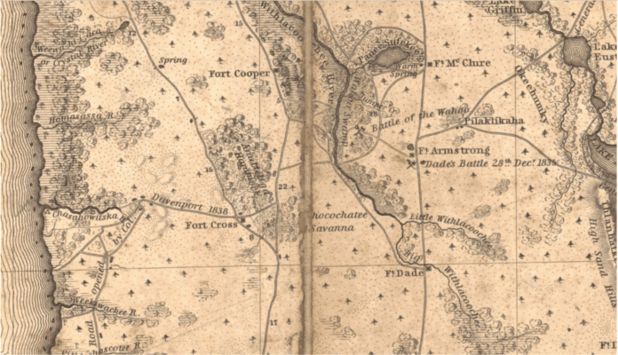
Hernando County is the home of several forgotten forts: Fort Cross, Fort Annutteliga, and Fort De Soto. The purpose of these forts was to protect the early settlers from Indian attacks and to provide a base from which the army could operate.
Fort Cross
Fort Cross was established around 1839 and closed in 1840. It was reopened a short while later to provide supplies to the settlers. The fort was said to be made of logs laid on an earthen embankment. The fort was maintained by a detachment of soldiers from “Company F, 4th Infantry.” There does not appear to be an agreed upon location of where the fort resided. Different historians have suggested locations for the fort along State Road 50. Roger Landers suggested it was located near the present day Bayfront Hospital. Other historians place its location near the Suncoast Expressway or a couple miles to east of the Suncoast Expressway. The General Land Office (GLO) map of the area from 1847 shows a road notated as the “Road from Clear Water Harbor to Fort Cross.”
It is important to locate the exact location of Fort Cross, it may be in the area set for the Cemex mine expansion and if its location is known it can be preserved.
Fort Annutteliga
Fort Annutteliga was situated near Stafford Lake according to maps of the time. Stafford Lake is located Northwest of the intersection of US 98 and Lake Lindsey Rd.
The Fort Annutteliga is mentioned in a letter to Major Belknap in Camp McCall on March 1st 1842 near the end of the Second Seminole War:
“Major: The Setlers [sic] who are to take post at the Annutaliga have reached there in safety and the troops are assisting them in the erection of two block houses, about forty of their numbers carry arms. This is an important move and will answer a better purpose towards closing the war than the quartering of two companies at Fort Cross.”
Fort De Soto
The best known of the these forts is Fort De Soto. It was a military settlement named after Hernando De Soto, and established in 1840. Its purpose was to protect settlers from the Seminole Indians, but it grew to a small community that housed a trading post and became a regular stagecoach stop on the way to Tampa. The community moved south because the limestone around the fort made it difficult to get water. This community eventually became Brooksville.
This area isn’t marked with any historical site plaque, and there aren’t any remains of settlement to visit, but it did exist all the same. Fort De Soto was located in the North East corner of present day Brooksville, on Croom Road about one-half mile east of U.S. Highway 41. The property is currently owned by Edwin House. Historian Frasier Mountain recalls a wood sign over the entrance to the House property marked Desoto.The approximate coordinates of the old De Soto stage stop are 28.56795,-82.3863694. Mr. Mountain also mentioned that the stage stop was rumored to have been a place that Hernando De Soto camped as he explored Florida.
Fort De Soto is the oldest settlement in Hernando County. On February 27, 1843 two years prior to Florida joining the Union, Hernando County was deemed a county. Fort De Soto was named the county seat. N.G. Rowe was one of the early settlers and served as postmaster for the fort. Other early settlers included D.F. Thresher, and W.R. Mills.
Camps and Blockhouses
In addition to the forts there were also Camps or Blockhouses for defense in many of the local communities. Often these blockhouses also doubled as a church and community center. According to James Covington “Military camps were established between 1836 and 1837 at Camp Lindsay, Camp Allen, and Camp Broadnax. Civilian forts or blockhouses also were constructed to shelter the pioneer settlers.”
UPDATE: According to a long time Brooksville resident across Cortez Blvd from Bayfront Hospital in the proposed mining site there used to be signs that this was the site of Fort Cross and an Indian village. The signs have long since disappeared.

