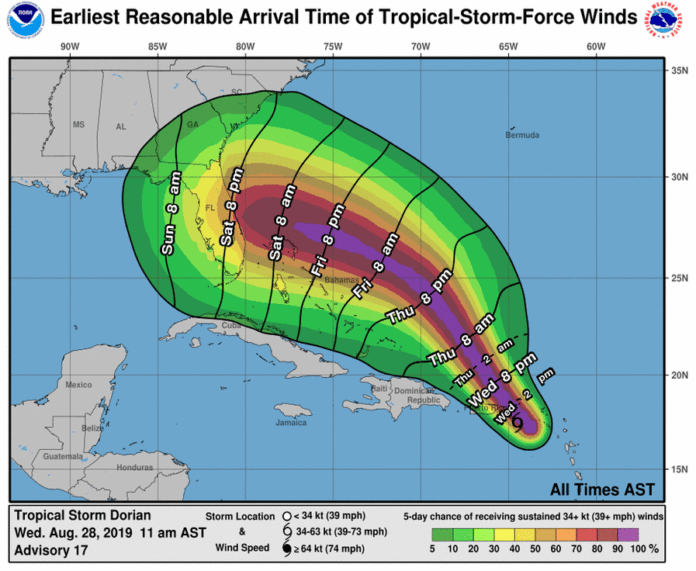
Dorian has now been upgraded to a hurricane with maximum sustained winds near 75 mph. The center of Hurricane Dorian is located near latitude 18.3 north, longitude 65.0 west. Dorian is moving toward the northwest at 13 mph, and this motion is expected to continue for the next day or two. On this track, Dorian should continue to move near or over the U.S. and British Virgin Islands this afternoon and then move over the open Atlantic well east of the southeastern Bahamas. Dorian is forecast to continue strengthening during the next few days over the Atlantic waters.
Dorian does not pose a threat to Florida until Saturday morning, at the earliest. The entire Florida Peninsula, Northeast Florida and the Big Bend are included in the 5-day forecast cone. There are no watches or warnings in effect, but tropical storm or hurricane watches could be issued on Thursday.
Dorian is forecast to be a Major Category 3 (or higher) Hurricane with winds over 111 mph as it approaches Florida on Sunday. Heavy rainfall of 4 to 8 inches is forecast across the Florida Peninsula. Damaging winds, flash flooding, river flooding, storm surge and isolated tornadoes are all possible this weekend statewide. Confidence has increased in the intensity forecast this weekend, but the exact track remains uncertain. All locations in Florida should continue to monitor Dorian for possible impacts over the Labor Day Weekend.

