CURRENT SITUATION
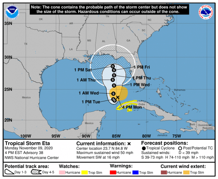
The center of Eta is located about 210 miles southwest of Fort Myers, moving southwest at 14 mph. Maximum sustained winds are near 50 mph. The center of Eta will continue moving away from the southwest Florida coast through the afternoon/evening hours. Eta is no longer forecast to become a Category 1 hurricane over the Gulf of Mexico but remain a tropical storm.
There is uncertainty in the forecast track for later this week and additional shifts in the track are likely. How far north and east the storm tracks will greatly influence where, when, and how much these impacts will affect our area. The latest advisory from the National Hurricane Center indicates the forecast for our area is improving.
Wind: As of the current forecast, Hernando County has a 10 to 20% chance of receiving tropical storm force winds (sustained winds greater than 39 mph). The most likely time of arrival is Thursday morning.
Surge: Wednesday through Friday, if Eta tracks closer to the coast, we could see 2 to 3 feet above normal tides (mean high high water).
Rain: One inch or less of rain is forecast for our area through Wednesday. However, any changes in the forecast track is likely to also change the rainfall forecast.
It is important that residents monitor the progress of this system over the next several days. Residents are also encouraged to refresh their emergency supply kits and ensure that their disaster plan is in place.
RECOMMENDED ACTIONS
Register for automated severe weather notifications at http://www.AlertHernando.org
Take this opportunity to refresh your emergency supply kit. For more information, visit http://www.HernandoCounty.us/EM
Residents are encouraged to monitor local media outlets or the National Weather Service at https://www.weather.gov/tbw/ for current weather information.
Test your weather radio today and change the battery if needed.

