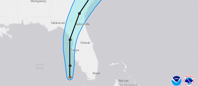
“Today is our game day,” Acting Emergency Director Erin Thomas said as she opened her update on Tropical Storm Elsa and the county’s emergency response.
Coastal residents should be particularly mindful of Elsa, which is expected to cause a 3-5 foot storm surge. According to Thomas, a 3 foot storm surge will cover Pine Island Drive. Hernando county will begin to experience tropical storm force winds around 39 MPH beginning mid-evening and overnight. The storm is expected to be over our area for 9-12 hours.
Flood watches and warnings are currently in effect due to recent heavy rainfall, this storm is expected to cause flooding in already saturated and low-lying areas. Elsa comes with a threat for tornado activity as well.
Storm surge is expected as the eyewall passes north of Hernando county. Thomas reported that the best window for storm surge will be between 1AM and 11AM Wednesday, July 7th. She cautions residents to turn on NOAA Weather Radios since this takes place when many are asleep.
As of 9AM, Elsa has moved off the north coast of Cuba and ambles northwest at 12 MPH. She is currently 250 miles south of Tampa. Sustained winds are now 60 MPH, and expected to reach 65 MPH as it approaches landfall somewhere north of Hernando county. Thomas reported that there has not been any changes to Elsa’s track, and that the current track comes with a “high confidence.”
The storm’s intensity, however, does not come with the same level of confidence. Thomas advised, “It’s important to note that there’s not a heck of a lot of difference between a high-end tropical storm and a low-end hurricane. Just a difference of a few miles (per hour) in wind speed.”
Thomas states that new areas of flash flooding associated with the storm have been identified, and cautions residents not to drive through standing water. She added that no one should be out after dark this evening.
Register for real time email and phone alerts: alerthernando.org

