By Jim Turner
©2022 The News Service of Florida.
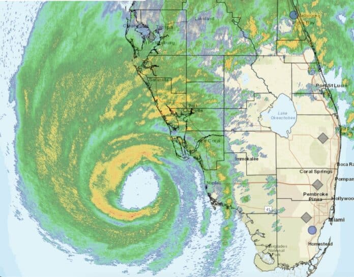
TALLAHASSEE — Gov. Ron DeSantis said Wednesday morning the time for Southwest Florida residents to evacuate had passed, as Hurricane Ian approached the Gulf Coast as a nearly Category 5 storm.
“This one has just strengthened and strengthened, and it is the real deal,” DeSantis said during a briefing at the state Emergency Operations Center in Tallahassee. “So, it’s going to do a lot of damage. So, people should be prepared for that.”
DeSantis said people in the storm’s immediate path are “already in hazardous conditions” and need to “hunker down, treat it like a tornado.”
With wind, rain and flooding expected to cause widespread damage as Ian crosses the state, DeSantis said “this is going to be a nasty, nasty day, two days.”
Ian was on track Wednesday morning to make landfall on the Charlotte County coast. The National Hurricane Center repeatedly used the word “catastrophic” in its morning advisories.
With extensive damage expected to infrastructure, DeSantis said most of the 2.5 million people ordered to evacuate have “by and large,” abided by the directive.
More than 30,000 utility workers are poised to restore power after Ian moves through the state, with some already working on outages.
The National Hurricane Center forecast that Ian — which was approaching a Category 5 rating Wednesday morning on the Saffir-Simpson Hurricane Wind Scale — will creep across Central Florida and exit into the Atlantic Ocean by late Thursday.
“There will be tropical-storm force winds, strong tropical-storm force winds felt all the way through the central part and up in Northeast Florida,” state Division of Emergency Management Director Kevin Guthrie said.
At dawn Wednesday, Ian was less than 100 miles west-southwest of Naples packing 155 mph maximum sustained winds and higher gusts, while moving as a mass at 9 mph to the north-northeast. Category 5 is reached when maximum sustained winds hit 157 mph.
Millions of Floridians are expected to feel the brunt of the storm, as hurricane-force winds extend 40 miles from the center and tropical storm-force winds go out 175 miles.
Storm surge is predicted to cause normally dry areas near the coast to flood, with high waters in areas such as Charlotte Harbor, Tampa Bay, the Lower Keys and the Atlantic Coast from the Volusia and Flagler County line to Savannah, Ga. Other waterways, such as the St. Johns River and Suwannee River, also are expected to rise.
“The deepest water will occur along the immediate coast near and to the right of the center (of the storm), where the surge will be accompanied by large waves,” the hurricane center said in a morning advisory. “Surge-related flooding depends on the relative timing of the surge and the tidal cycle, and can vary greatly over short distances.”
In a state where six property-insurance companies have been deemed insolvent since February, Ian is forecast to create “catastrophic wind damage” when it comes ashore, according to the hurricane center.
Florida is working with the Federal Emergency Management Agency, and 26 states have offered assistance.
The state Department of Transportation has 1,200 workers on standby to perform “cut and toss operations” to remove debris from roads.
The Florida National Guard has activated 5,000 members, and neighboring states have offered 2,000 more.
Port Tampa Bay, Port of St. Petersburg and SeaPort Manatee have temporarily ceased cargo operations.
To speed supplies after the storm, DeSantis said crews at Southwest Florida airports will ride out the hurricane and clear runways as soon as possible after Ian passes.

