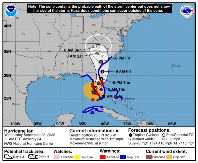
12:00 PM Update – September 28, 2022
Our apologies for the delay. Here is the latest press conference from the Hernando County Government. We urge everyone to finalize their evacuations and other storm preparations, as the county is under a Tropical Storm Watch and heavy wind and rain is expected.
8:00 PM Update – September 27, 2022
Storm Surge and Tropical Storm warnings are still in effect. Ian’s path has shifted north-northeast, threatening areas south of Tampa Bay. Hernando county residents are urged to remain vigilant. The storm is quite large, with hurricane force winds that currently extend 40 miles from the storm center, and tropical storm force winds that radiate 140 miles from the center.
5:00 PM Update – September 27, 2022
Storm Surge and Tropical Storm warnings are in effect. Storm surge warnings went into effect by the National Weather Service (NWS) at 2:16 PM for Hernando Beach, and Bayport. The latest Tropical Storm warning at 5:27 PM affects Brooksville, Spring Hill and High Point.
The latest local forecast is for below tropical storm force winds of 25 – 35 MPH with gusts up to 60 MPH.
2:00 PM Update – September 27, 2022
According to the National Hurricane Center (nhc.noaa.gov), a Storm Surge Warning is in effect for Tampa Bay. In the latest advisory, the NHC reports:
“Maximum sustained winds have increased to near 120 mph (195 km/h) with higher gusts. Ian is a category 3 hurricane on the Saffir-Simpson Hurricane Wind Scale. Re-strengthening is expected later today through Wednesday.
Ian is forecast to approach the west coast of Florida as an extremely dangerous major hurricane.
Hurricane-force winds extend outward up to 35 miles (55 km) from the center and tropical-storm-force winds extend outward up to 140 miles (220 km).
The minimum central pressure has dropped to 955 mb (28.20 inches) based on Air Force Hurricane Hunter data.”
11:00 AM Update – September 27, 2022
Ian’s path has been updated to make landfall south of Tampa Bay. Be advised the storm path is not absolute. The storm itself is large, and will impact Hernando county even if does not make landfall here.
Press conference of the Hernando County Government Emergency Operations Center
10:00 AM Update – September 27, 2022
Press conference of the Hernando County Government Emergency Operations Center
5:00 AM Update – September 27, 2022
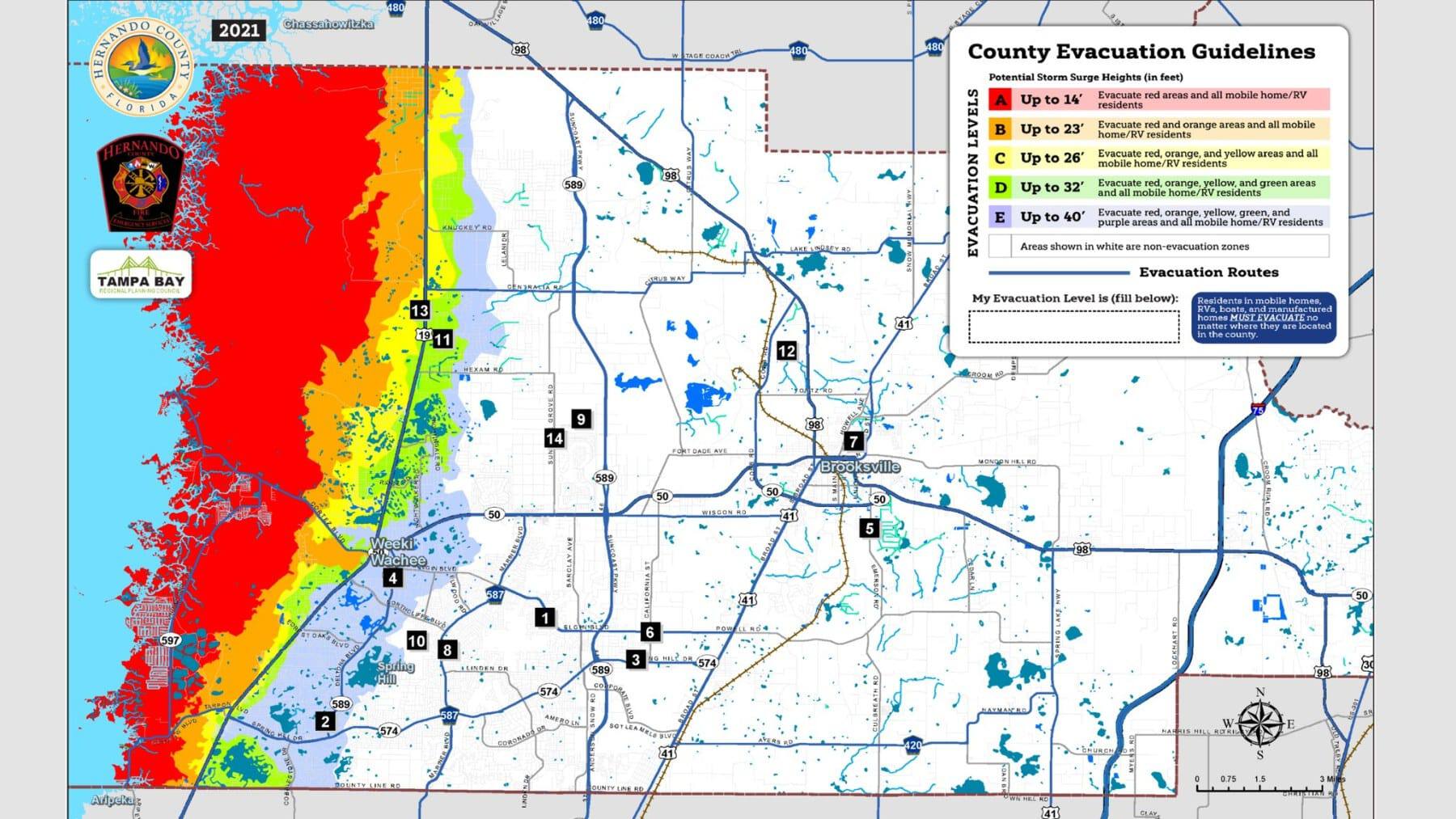
As of today, schools and Government offices will be closed for the remainder of the week. Mandatory evacuation orders begin at 9:00 AM for residents in Zone A, and all those residing in manufactured homes
Shelters Available:
- Mining Association Enrichment Center: General Population and pet friendly — 800 John Gary Grubbs Blvd, Brooksville, 34601
- Challenger K-8: For those with special needs and their families only — 13400 Elgin Blvd, Spring Hill, 34609
- Explorer K-8: General population and pet friendly — 10252 Northcliffe Blvd, Spring Hill, 34608
Sandbags are now available beginning at 9:00 AM on today, Tueseday, September 27, 2022 at the Ridge Manor Community Center: 34240 Cortez Blvd, Ridge Manor, FL 33523
Sandbags are available at Linda Pedersen Park and Anderson Snow Park: https://www.hernandosun.com/2022/09/25/self-serve-sandbag-sites-are-open-to-help-prepare-for-the-upcoming-hurricane/ You can find preparation tips in our June article, “Bracing for a Hurricane” https://www.hernandosun.com/2022/06/13/bracing-for-a-hurricane/
11:00 PM Update – September 26, 2022
As of today, the Hernando County Government has issued a State of Emergency order for the county. Schools and Government offices will be closed for the remainder of the week. Voluntary evacuation orders are in effect for residents in Zone A, and all those residing in manufactured homes. Zone A is primarily on the west side of Highway 19 / Commercial Way. Mandatory evacuations begin tomorrow morning at 9:00 AM.
Shelters Available:
- Mining Association Enrichment Center: General Population and pet friendly — 800 John Gary Grubbs Blvd, Brooksville, 34601
- Challenger K-8: For those with special needs and their families only — 13400 Elgin Blvd, Spring Hill, 34609
- Explorer K-8: General population and pet friendly — 10252 Northcliffe Blvd, Spring Hill, 34608
Sandbags are now available beginning at 9:00 AM on Tuesday, September 27, 2022 at the Ridge Manor Community Center: 34240 Cortez Blvd, Ridge Manor, FL 33523
Sandbags are available at Linda Pedersen Park and Anderson Snow Park: https://www.hernandosun.com/2022/09/25/self-serve-sandbag-sites-are-open-to-help-prepare-for-the-upcoming-hurricane/ You can find preparation tips in our June article, “Bracing for a Hurricane” https://www.hernandosun.com/2022/06/13/bracing-for-a-hurricane/
8:00 AM Update – September 26, 2022
Ian has become a Category 1 hurricane overnight, with maximum sustained winds near 75 MPH. The latest advisory from the National Hurricane Center (nhc.noaa.gov) indicates that a “Storm Surge Watch has been issued for the Florida Keys from the Card Sound Bridge westward to Key west, including the Dry Tortugas, and for the west coast of Florida from Englewood southward to the Card Sound Bridge, including Florida Bay.
A Tropical Storm Watch has been issued for the west coast of Florida from Englewood southward to Chokoloskee.”
Closer to home, sandbags are now available at Linda Pedersen Park and Anderson Snow Park: https://www.hernandosun.com/2022/09/25/self-serve-sandbag-sites-are-open-to-help-prepare-for-the-upcoming-hurricane/ You can find preparation tips in our June article, “Bracing for a Hurricane” https://www.hernandosun.com/2022/06/13/bracing-for-a-hurricane/
11:00 PM Update – September 25, 2022
Ian’s potential path seems closer to Florida’s west coast at this hour. The following is from the latest advisory from the National Hurricane Center (nhc.noaa.gov): “A Tropical Storm Warning has been issued for the lower Florida Keys from Seven Mile Bridge westward to Key West, including the Dry Tortugas.
A Storm Surge Watch has been issued for the Florida Keys from the Card Sound Bridge westward to Key west, including the Dry Tortugas, and for the west coast of Florida from Englewood southward to the Card Sound Bridge, including Florida Bay.
A Tropical Storm Watch has been issued for the west coast of Florida from Englewood southward to Chokoloskee.”
Closer to home, sandbags are now available at Linda Pedersen Park and Anderson Snow Park: https://www.hernandosun.com/2022/09/25/self-serve-sandbag-sites-are-open-to-help-prepare-for-the-upcoming-hurricane/ You can find preparation tips in our June article, “Bracing for a Hurricane” https://www.hernandosun.com/2022/06/13/bracing-for-a-hurricane/
8:00 PM Update – September 25, 2022
Still a Tropical Storm, Tropical Storm Ian’s path remains steady. Sandbags are now available at Linda Pedersen Park and Anderson Snow Park: https://www.hernandosun.com/2022/09/25/self-serve-sandbag-sites-are-open-to-help-prepare-for-the-upcoming-hurricane/ You can find preparation tips in our June article, “Bracing for a Hurricane” https://www.hernandosun.com/2022/06/13/bracing-for-a-hurricane/
5:00 PM Update – September 25, 2022
Still a Tropical Storm, Tropical Storm Ian’s path remains steady. Sandbags are now available at Linda Pedersen Park and Anderson Snow Park: https://www.hernandosun.com/2022/09/25/self-serve-sandbag-sites-are-open-to-help-prepare-for-the-upcoming-hurricane/ You can find preparation tips in our June article, “Bracing for a Hurricane” https://www.hernandosun.com/2022/06/13/bracing-for-a-hurricane/
2:00 PM Update – September 25, 2022
Still a Tropical Storm, there is no clear change in Ian’s track since our last update. Sandbags are now available at Linda Pedersen Park and Anderson Snow: https://www.hernandosun.com/2022/09/25/self-serve-sandbag-sites-are-open-to-help-prepare-for-the-upcoming-hurricane/ You can find preparation tips in our June article, “Bracing for a Hurricane” https://www.hernandosun.com/2022/06/13/bracing-for-a-hurricane/
11:00 AM Update – September 25, 2022
Not much change in Ian’s track over the last 3 hours. Sandbags are now available: https://www.hernandosun.com/2022/09/25/self-serve-sandbag-sites-are-open-to-help-prepare-for-the-upcoming-hurricane/ Other preparation tips to consider in our June article, “Bracing for a Hurricane” https://www.hernandosun.com/2022/06/13/bracing-for-a-hurricane/
8:00 AM Update – September 25, 2022
Ian is tracking slightly more to the west, however still keeping our west coast in the cone of uncertainty. It’s not too late to prepare! Helpful tips can be found in our June article, “Bracing for a Hurricane” https://www.hernandosun.com/2022/06/13/bracing-for-a-hurricane/
11:00 AM Original information:
According to the National Hurricane Center (NHC), Ian will continue strengthening into a Hurricane before churning its way across Western Cuba then north toward Sarasota and Manatee counties.
Ian is expected to enter the Gulf of Mexico after crossing western Cuba around 8 am Tuesday, and be classified as a Major Hurricane with wind speeds greater than 100 MPH.
Hernando county is in the zone of uncertainty, according to NHC predictions. Residents in this area are advised to take precautions.


