Forecasting weather disasters is not a simple task. How strong a tropical storm will grow or where it will head is determined by many weather factors, each of which can become highly unpredictable by the hour.
Every year, scientists at the North Atlantic Oceanic and Atmospheric Administration (NOAA) strive to provide us with a broad overview of how each season will pan out. They do this by tracking various oceanic and atmospheric patterns as well as drawing information from decades of statistics.
On May 25, 2023, NOAA forecasters predicted near-normal hurricane activity in the Atlantic Basin for 2023. Their outlook for the Atlantic hurricane season, which is from June 1 to November 30, predicted a 40 percent chance of a near-normal season, a 30 percent chance of an above-normal season, and a 30 percent chance of a below-normal season.
The forecast was for between 12 to 17 total named storms (winds of 39 mph or higher). Of those, 5 to 9 could become hurricanes (winds of 74 mph or higher), including 1 to 4 major hurricanes (category 3, 4, or 5, with winds of 111 mph or higher). NOAA stated a 70 percent confidence in these ranges.
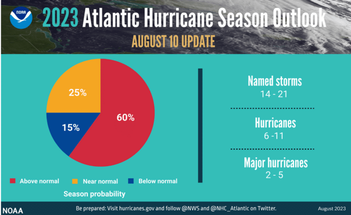
On Aug. 11, scientists updated their predictions for the Atlantic hurricane activity in 2023 – warning us that it is now likely to be an above-normal season with more storms and major hurricanes than seen in an average year. NOAA’s updated forecast also states that current conditions are likely to counterbalance the usually limiting atmospheric conditions associated with the ongoing El Niño event.
The new update which covers the entire six-month hurricane season that ends on Nov. 30 — calls for 14-21 named storms (winds of 39 mph or greater), of which six to 11 could become hurricanes (winds of 74 mph or greater). Of those, two to five could become major hurricanes (winds of 111 mph or greater). NOAA provides these ranges with a 70 percent confidence. These updated ranges include storms that have already formed this season.
Forecasters attribute the extra activity to record-high ocean temperatures and unusual wind patterns in the atmosphere, which enables the complex push-and-pull-effect that governs the development of hurricanes.
***
So far this year, the Atlantic Basin has seen an active start. On Jan. 16, the National Hurricane Center issued a special tropical weather warning as a low-pressure system developed north of Bermuda. It became an unnamed subtropical storm and dissipated the next day.
Now, at the peak of hurricane season, fourteen tropical or subtropical storms have been recorded, and a fifteenth storm is brewing in the middle of the Atlantic and North America. This storm will be called Nigel if it reaches tropical strength and will be the fifth hurricane this season. According to NOAA, the number of storms is more than 50 percent higher than normal for this date.
Last week, Hurricane Lee grew from a category one storm to a category five hurricane in 24 hours — it impacted New England as a tropical storm before making landfall in Nova Scotia as a near-hurricane- as reported by the AP. Hurricane Margot peaked as a hurricane and is expected to remain over water, not posing a threat to land.
In addition to Hurricane Nigel, which could become a major Category 3 storm over the open ocean in the days ahead, there are other multiple systems to keep an eye on.
There are two other areas of concern. One is a new tropical wave rolling off the coast of Africa that appears likely to develop as it travels west across the tropical Atlantic Ocean. The other is an anticipated area of storminess off the southeast U.S. coast, which could bring heavy rain and gusty winds to the southeast and Mid-Atlantic. The next named storm will be Ophelia.
Experts say we should expect more storms like Lee and its rapid intensification as the world’s climate continues to warm.
The season officially runs through Nov. 30.
Be prepared. Make sure your home is secure should a hurricane come your way.

