BROOKSVILLE, FL – On Tuesday, September 24, Hernando County Director of Emergency Management David DeCarlo held a press conference at the Hernando County Sheriff’s Office Emergency Operations Center and on Facebook Live regarding Tropical Storm Helene.
With the potential hurricane barreling towards the panhandle and the West Florida coast, the entire county is currently under a hurricane and storm surge watch, DeCarlo noted on Tuesday. Helene is expected to enter the Gulf of Mexico later this evening or early tomorrow morning. Once the cyclone enters the gulf, “rapid intensification and moving north is expected,” he said.
The county is anticipating a storm surge between 6 and 10 feet as Helene is predicted to make landfall anywhere between 2:00 PM and 8:00 PM on Thursday. As a result, DeCarlo and company have taken the following precautions:
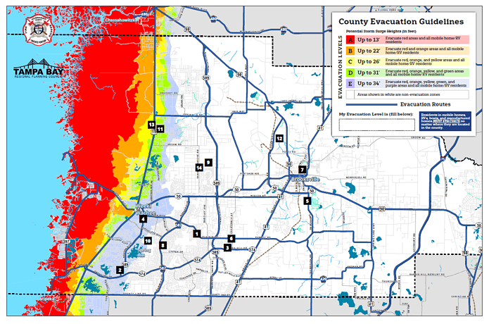
- A mandatory evacuation order is in effect beginning Wednesday, September 25 at 8:00 AM for the areas West of US-19, which includes evacuation zones A, B, and C in the county. This includes residents living in coastal or low-lying areas as well as manufactured homes across Hernando.
- Beginning Wednesday at 8:00 AM, the public shelters at West Hernando Middle School (14325 Ken Austin Parkway) are open, but space is limited. “They are a lifeboat, not a love boat,” DeCarlo stated. “These should be your last resort.” For those who bring their pets, the Emergency Director urges people to bring all necessary supplies. Citizens are advised to take shelter with family or friends if possible.
- Sandbags are available at various locations around the county, including Linda Pedersen Park, Anderson Snow Park, Ridge Manor Community Center, and Spring Lake Methodist Church. The sandbag stations are open from 8:00 AM through to 5:00 PM on Tuesday. They will open and close at the same time on Wednesday if the weather permits. Further information can be found at the Emergency Management tab on the county’s website.
With Hernando experiencing above-average levels of rainfall for this year up to this point, ground saturation is a concern. This may result in water failing to percolate down through the soil. If the storm surge and rain reach the higher ends of their projections, large volumes of standing water could be present.
There will be a “point of no return” for those weighing whether to stay or evacuate. Once the tropical storm force winds begin to bluster across Hernando, emergency services will stop. So, if residents need rescue on Thursday, they will have to wait out the night. Large-scale power outages are also a distinct possibility.
Further press conferences will be held on Wednesday at 10:00 AM and 6:00 PM. The Emergency Operations Center will be giving periodic updates throughout the duration of this storm on their Facebook page as they receive details from the National Weather Service and the National Hurricane Center. Information lines are now open to citizens at (352) 754-4083.
“We want people to understand and take this storm seriously,” DeCarlo said. “6 to 10 feet of storm surge is nothing to squawk about […] Please heed our warnings, take the evacuation seriously, find a safe place to refuge.”

